


Attempting to Climb Katahdin via "The Armadillo" (5.7)
Sometimes you take your rack and a rope for a walk without climbing

Four months ago, I made a four-night reservation at Baxter State Park for a backpacking and climbing trip with my wife, Whitney. The plan was to drive to Maine, spend a night at the trailhead Roaring Brook campground, and then hike to the Chimney Pond backcountry campground to bivy for three nights. While in the backcountry, we would have two climbing days to attempt our climbing objective, an alpine rock route called the Armadillo (5.7).
Unfortunately, due to rainy and wet conditions, we could not climb the route. (At the time of writing this, I am still a bit sick about getting shut down. Hopefully, by the time this post is published, I will have moved on.) Nonetheless, our trip is still worth a write-up. So here it goes.
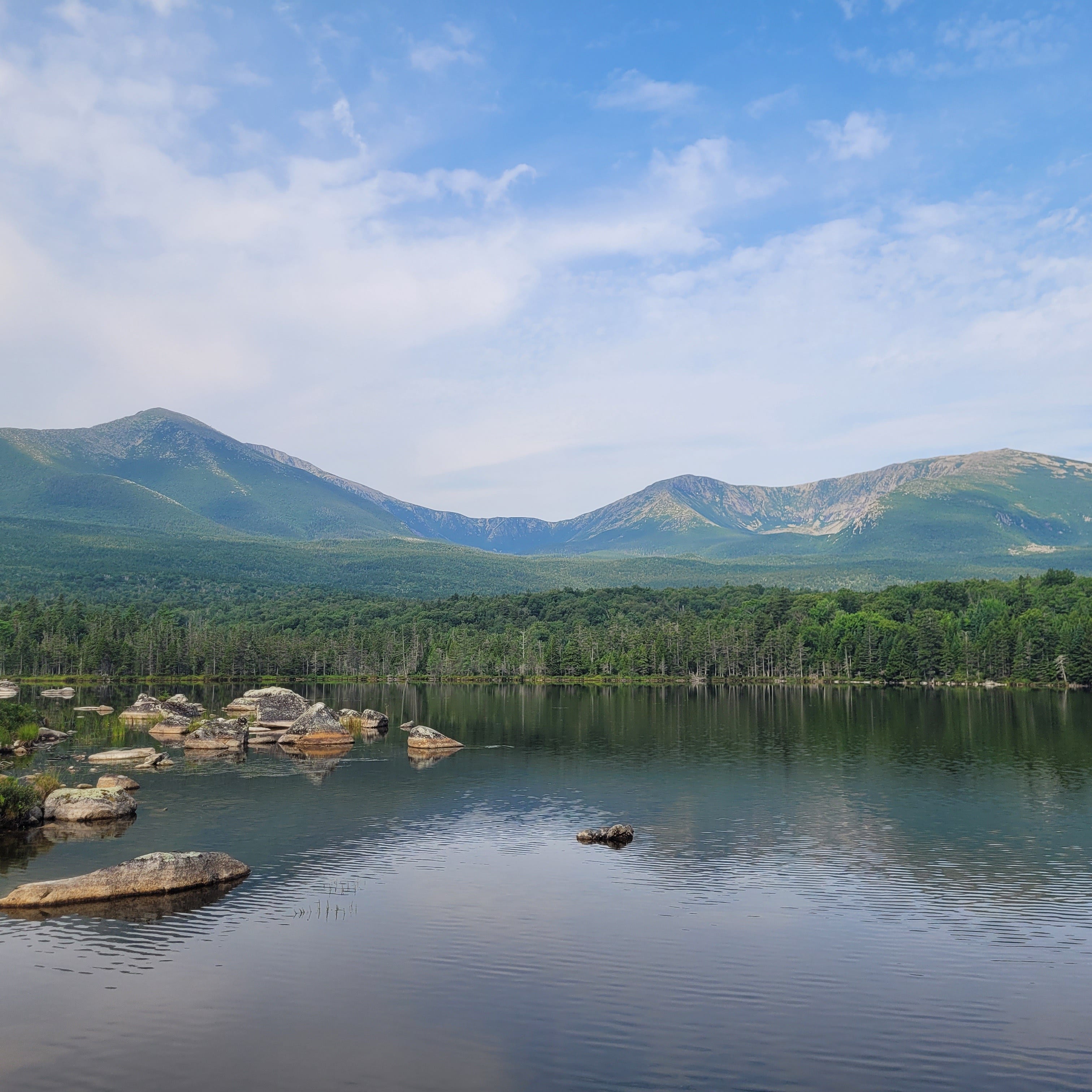
Katahdin of Baxter State Park
Katahdin, which translates to “the greatest mountain,” is found on sacred land that once belonged to the Penobscot Indigenous Nation. Pre-contact from colonizers, the Penobscot people inhabited Maine and surrounding areas for thousands of years.
For the Penobscot Nation, Katahdin is considered a place of spiritual enlightenment. While they hunted and gathered around the mountain's surrounding regions, they cautioned against ever summiting the mountain. They believed that an evil spirit named Pamola (which translates to “he who curses the mountain,) would either kill or devour them.
Nowadays, the Penobscot Nation (pronounced Pαnawάhpskewi in the Abenaki indigenous language) is a federally recognized tribe that still inhabits the area. However, they are no longer in possession of their sacred mountain. After almost a century of colonization, the Penobscot Nation ceded the majority of its lands through illegal and unconstitutional treaties, leaving it with only the Penobscot Indian Island Reservation.
Much later, in 1930, the ex-Governor of Maine, Percival P. Baxter, purchased 6,000 acres of land, including the mountain. A year later, in 1931, Baxter donated the parcel of land to the state of Maine. In subsequent years, Baxter purchased more land and pieced together the State Park.
Since then, additional purchases and land gifts have increased the Park’s total size to 209,644 acres. About 75% of the Park (156,874 acres) is managed as a wildlife sanctuary. In the northwest corner of the Park 29,537 acres (about 14% of the Park) was designated by Governor Baxter to be managed as the Scientific Forest Management Area. In addition, about 25% of the Park (52,628 acres) is open to hunting and trapping with the exception that Moose hunting is prohibited in the Park.
The Climbing Objective
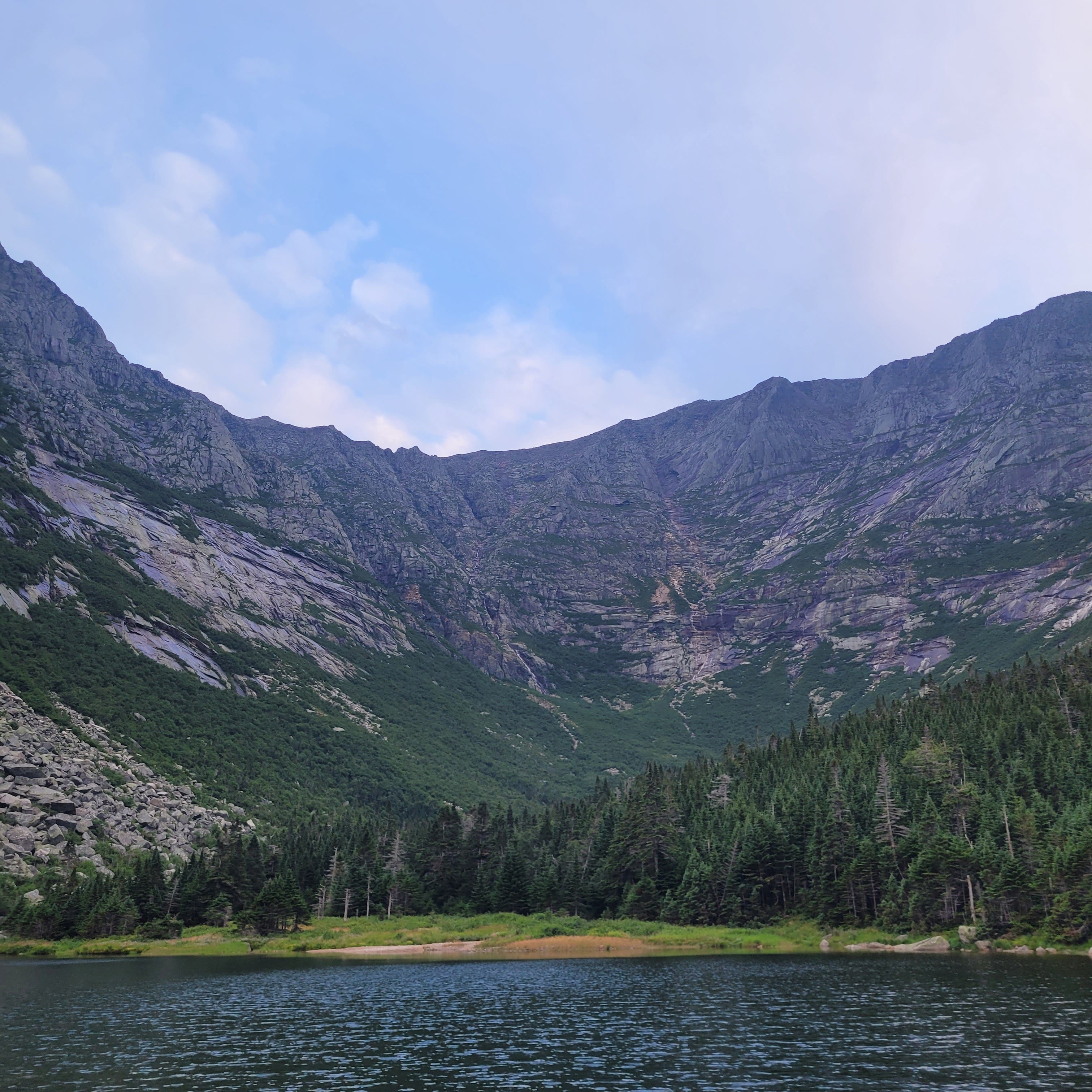
Two glacial cirques—the North Basin and the Great Basin (also known as the South Basin)—are located along the Katahdin massif's eastern flanks. Our objective, the Armadillo, is found in the upper reaches of the South Basin. It faces due east and contains at least six pitches of climbing. From the bottom of the cirque, the Armadillo looks like a humongous pyramid with an impressive ridgeline that reaches upward to the summit of Katahdin.
The Armadillo is one of those alpine climbs where you might spend more time hiking to and from the climb than you will actually climbing the thing. Plus, the approach is notorious for being the hardest part. Nonetheless, having spent a lot of time out West climbing and hiking in the Rockies, Whitney and I felt like it was within our wheelhouse.
Why We Could Not Send
Upon our arrival at Baxter State Park, the forecast for our climbing days looked relatively good. There was supposed to be some rain and potential for lightning and thunder in the afternoons. This meant that if we were up early enough, we should be able to knock out the climb and return to camp before the afternoon storms. However, what we did not consider in our forecasting was the rain that poured in the days prior.
Plus, on the evening of our arrival, it rained an inch. During the storm, we hid out in our lean-to, feeling full of ourselves that we avoided getting stuck in the rain. Afterward, drawn to the newfound droning sound we heard coming from up the valley, we went out to the pond to see rivers and full-blown waterfalls had formed and were catapulting water down the myriad gullies in the cirque and draining into the pond. It was beautiful. An ephemeral display of waterworks caused by the precipitous storm.

However, thanks to the steady breeze that blew through the cirque, the short duration of the intense storm, and the strategic positioning of the Armadillo high above any of the rivers and waterfalls we saw cascading downward, revealing what looked to be dry rock, we thought we could still carry out our plan the following day.
We planned for an eight-hour day, starting at 5am, which would get us back around midday. I woke up at 3:45 am to prepare breakfast and coffee. We prepped all the other equipment the night prior and had one small backpack for each of us. Meanwhile, Whitney slept in until 4 am. By 5 am sharp, we were beginning the approach, which turned out to be quite the wake-up call and foreboding foreshadowing of our morning ahead.
The approach began with rock hopping around the perimeter of Chimney Pond. This was supposed to be an easy and scenic foray into what would become a hard approach. However, the pond's super high water level made the rock hopping extra technical and slowed our progress. (However, it was incredibly scenic.)
To make matters worse, after we finished circumnavigating the pond, the dry riverbed we were supposed to follow up the valley towards the Armadillo was a complete rushing river. With legitimate white water conditions, following the river along its rocky and supposedly dry river banks was impossible. Instead, we were forced into the dense thickets of pine trees on the river’s flanks.

The ensuing bushwhack brought a whole new meaning to bushwhack. The gaps between the trees were so tight that branches clung to our equipment, poked holes in our shirts, and scraped our exposed arms. In terms of what we were walking on, we were lucky if it was soil. Most of the time, we balanced over rotten piles of deadfall and hopped over talus boulders with seemingly bottomless pits in between them. These conditions made for excruciatingly slow progress.
To make matters worse, we felt lost or that we missed something critical. That was probably because at no point do you feel you’re going the right way in a bushwhack that rough. Plus, the dry river bed we were told about was definitely not dry, making us believe that maybe we were headed up the wrong one. So, we were second-guessing ourselves despite being confident in our backcountry navigation skills.
At one point in the approach, after reaching somewhat of a clearing where we could get a vantage point, we were shocked by the little progress we made and how much further we needed to go to even exit this portion of the approach. After the bushwhack, we still needed to navigate a detour around the side of the cirque headwall to gain access to the upper slabs. From that point, we needed to ascend a ramping gully system to get to the base of the climb. From our vantage, this section of the approach looked to be seeping with water.
Feeling intimidated by what lay ahead, we considered turning around. If we continued ahead, the day would stretch out well beyond our eight-hour time frame, and with the stability of the daily forecast in question, we were unsure if that would be safe. Plus, even if we did make it off the valley floor, the looming wet slabs in the next portion of the approach looked improbable.
So, as a team, we made the painstaking decision to cut our losses and turn our tails back to camp. On the way back, I admit, I threw a bit of a temper tantrum. There was some audible cursing involved as we repeated all the horrendous bushwhacking we just survived. Meanwhile, intense emotions of frustration, disappointment, and naivete crept up on me. I felt bad for dragging Whitney into this and incapable of guiding her. I couldn’t stop thinking about the wasted time, not just from that morning but all the time prior in the trip-planning phase of our expedition. I felt like a quitter.
Lessons Learned from Bailing
While I wish I could tell you I learned a lot about the specific interworkings of approaching, climbing, and descending from the Armadillo, I cannot. However, that does not mean that our trip to Katahdin was in vain. Despite not being able to climb the Armadillo, I still learned a lot from our trip.
Expedition Planning
Due to the Armadillo’s remote location within Baxter State Park, I chose to organize a multi-day climbing expedition instead of a car-to-car, smash-and-grab ascent. I got good practice with expeditionary tactics like:
pre-trip and on-route planning
meal planning and rationing
packing additional backpacking gear (i.e., sleep system, cook system)
water harvesting and filtration
streamlining my climbing equipment for light and fast alpine-style climbing
front and backcountry navigation
Baxter State Park Logistics
Baxter State Park is infamous for being hard to deal with. The reason is that its governance practices prioritize wilderness conservation instead of recreation. (I think is cool until you want to recreate there.) Then, once inside the park, you almost get the feeling that the people running the place would be perfectly fine without you being there.
It’s also an incredibly popular place for hiking and backpacking (the summit of Katahdin is the north terminus of the Appalachian Trail), so many people compete for use. To control crowds, the park relies on strict reservation policies. Plus, the Park unabashedly prioritizes Maine residents for day-use and overnight reservations compared to out-of-state folks.
All of this is to say that dealing with Baxter State Park is clunky, fickle, and unique compared to other state parks and climbing destinations. Now that I’ve done it once, I’m much more apt to handle it a second time.
Bailing Isn’t Quitting
After calming down and taking a nap, much like a baby, I came to terms with the most important thing I learned from our trip: bailing is not quitting. Bailing is making the gut-wrenching decision to go down based on a slue of factors that tip your risk management decision-making towards safety and away from the summit.
Sometimes, you have to do down, no matter how much you prepped or planned or how much money you spent to be there. Sometimes, your grand adventure amounts to nothing but a walk in the wilderness with a backpack full of climbing gear and a rope. I’ve bailed on other objectives before, but I think bailing on the Armadillo really drove this point home for me.
So What Did We Do? We Activated Plan B

Despite bailing on our main objective, we still had a good day. We returned to the lean-to and fell back to sleep; after waking up a second time at a more reasonable hour, we decided to explore nearby hiking trails. We had a wonderful lunch in Blueberry Knoll and enjoyed impressive vistas of the North Basin and the Taber Wall. In the afternoon, we took naps, ate more food, and copiously read our books. We also planned what we wanted to do for the next day.
Originally, the second climbing day was supposed to be for more climbing after checking off the Armadillo. However, considering the cirque was still dripping wet, and an overnight forecast of another 1/2 inch of rain, we opted to go hiking instead.
The following morning, we took the Dudley Trail up to the peak of Pamola (4,919 feet above sea level). From there, we scrambled over the infamous Knife Edge to summit South Peak and, eventually, Baxter Peak (the anglicized summit of Katahdin, 5,268 feet). It was a wonderous, full-value day.
Yes, at many points, I wished I was rock climbing. (Especially when I was gazing down on the Armadillo from the ridge, admiring what I assumed to be fantastic alpine climbing.) But all in all, it was hard to complain. I was in the mountains, feeling very much alive and inspired, and sharing the experience with Whitney.
That rock has been there a long time, and it will continue to be there. I will be back. So, with that being said, does anyone want to go to Baxter State Park?


